
SCDNR extends hunting closure in Santee River drainage; Wateree-Congaree closure to expire
Due to extreme high river levels and widespread flooding resulting from the devastating effects of Hurricane Helene, the South Carolina Department of Natural Resources is declaring an extension to the temporary closure for hunting within portions of the Santee River drainage systems on all game species except for alligator, doves, hogs and coyotes.
For the affected area of the Santee River drainage, there will be a three-day extension of the closure. This extension goes into effect at 11:59 p.m. on Sunday, Oct. 6, 2024 and will continue until 11:59 p.m., Wednesday, Oct. 9, 2024.
Flood waters are receding upstream of Lake Marion and the temporary closure affecting portions of the Wateree and Congaree river drainages will expire as previously scheduled at 11:59 p.m. on Sunday, Oct. 6.
As historic level water flows continue to make their way downstream from the mountains and piedmont of the Upstate and North Carolina, river levels below the Wilson (Lake Marion) Dam are expected to crest this weekend at levels exceeding any recorded since the construction of the dam in 1941. These rising water levels in the Santee River continue to create potential for exploitation of game species that are deprived of their normal escape routes and confined to small areas of high ground.
The closure zone not only includes the areas inundated with water but also the adjacent dry land and high ground where deer and other wildlife congregate and are vulnerable. In these situations, wildlife have been pushed out of their normal home range and are often disoriented, exhausted or limited in their ability to travel normally.
SCDNR will continue to monitor flooded areas to adjust the closure zones and timeframes as conditions change.
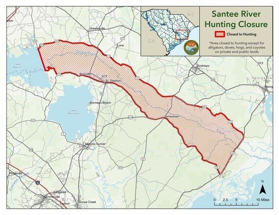
SANTEE DRAINAGE:
In BERKELEY COUNTY- that area bounded on the north by Clarendon, Williamsburg and Georgetown Counties; on the south by S.C. 45; on the west by the old Santee Canal; and the east by Charleston County.
In CHARLESTON COUNTY: that area bounded on the west by Berkeley County; on the south by S.C. 45, on the east by US 701/17, and on the north by Georgetown County.
In GEORGETOWN COUNTY- an area described as follows: beginning at the point where the Williamsburg, Berkeley and Georgetown County lines meet and running north and east along the Georgetown-Williamsburg County lines to U.S. Alternate 17 and thence running along such highway to its intersection with state road 387, thence to state road 24, and running southeast along state road 24 to its intersection with U.S. 17, thence south along U.S. 17 to the Charleston County line, thence west following the Charleston and Berkeley County lines to the point of the beginning.
In WILLIAMSBURG COUNTY- the area described as follows: beginning at the point where state road 48 (River Rd.) crosses the Clarendon County line and following state road 48 until its intersection with S.C. 375 (Mackey Rd./Gourdin Rd.), thence running along said road to Gourdin, thence along state road 45 (Santee Rd.) to the Georgetown County line, thence south along such line to the Berkeley County line and following said line northwest to the Clarendon County line, thence northeast along said Clarendon County to state road 48.
In CLARENDON COUNTY- that area described as follows: beginning at the intersection of S.C. 260 and state road 323 (Kenwood Rd.), and running along state road 323 to its intersection with state road 351, thence running along state road 351 to state road 48, thence along state road 48 to the Williamsburg County line, thence along said county line to the Berkeley County line thence west along the Clarendon/Berkeley County line to Wilson Dam, thence north along said dam to S.C. 260, thence along S.C. 260 at state road 323.